- Arizona State University
- LibGuides
- Indigenous Food Systems
- Indigenous Nations
Indigenous Food Systems: Indigenous Nations
Overview
Intention
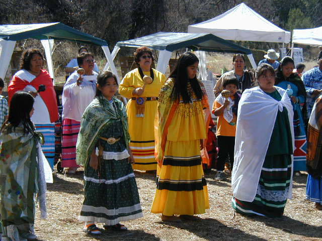
Below is a brief introduction to the 23 nations and tribes in Arizona (the state name derives from the O’Odham name alĭ ṣonak, meaning "small spring”). The aim is to educate readers about the histories and present happenings of these nations.

We aim to highlight the distinctness of each nation, alongside similarities in values and beliefs, with the understanding that Indigenous communities and individuals hold living heritages.
This tab was created by a non-Indigenous ASU student that did not directly consult with members of the below tribes when forming the sections but drew verbatim from the tribes’ website and this site.
Beginning on page 201 of Tiller’s Guide to Indian Country, there is an in-depth economic profile of each Arizona Indigenous Nation. The section about Agriculture & Livestock is detailed and linked for each tribe below. The book is available virtually via EBSCOhost and in hardcopy at ASU’s Labriola National Native American Indian Data Center (the book can be reviewed at the Center, but cannot be checked out).
(Click the images for each tribe to be taken to the source link)
Ak-Chin Indian Community
- Ak-Chin is an O’odham word that means “mouth of the wash” or “place where the wash loses itself in the sand or ground.”
- The Ak-Chin Indian Community lies 35 miles south of Phoenix in northwestern Pinal County.
- One of the main enterprises in the region is Ak-Chin Farms and, now with over 15,000 acres of productive land, is one of the largest farming communities in the U.S.
- Today, their farming operations grow cotton, alfalfa, barley, potatoes, and corn, alongside the Hickman’s Egg Farm, which houses 230,000 chickens for egg production.

Fort McDowell Yavapai Nation
- The Yavapai people hunted and foraged food according to seasonal, communal movement in a vast area of Arizona’s desert lowlands and mountainous Mogollon Rim country.
- Located in Maricopa County, the Fort McDowell Reservation lies approximately 23 miles northeast of Phoenix on a small parcel of former ancestral land.
- Two important affirmations of tribal sovereignty happened when the Orme Dam’s construction was blocked, with community members spearheading an opposition campaign, and when tribal community members fought back against an FBI raid of a tribal casino, which then paved the way for Indian gaming.
- There is a 2,000 acre tribal farm and nursery where 1,000 acres of pecan trees, 325 acres of citrus trees, and 620 acres of alfalfa are grown.

Gila River Indian Community
- Gila River Indian Community (GRIC) traces its roots to the Hohokam, prehistoric Indians who lived and farmed along the Gila River Basin centuries ago, today being composed of two members of tribes, the Pima and Maricopas.
- The reservation is located in Maricopa County south of Phoenix, Tempe, and Chandler.
- The people who now reside within GRIC are in the planning stages of an irrigation project that will establish an irrigation system to deliver water to 146,300 acres of farmland.
- Today, 15,000 acres of tribal land grow cotton, wheat, millet, alfalfa, barley, melons, pistachios, citrus, and vegetables, 500 acres grows olives for worldwide distribution, while another 22,000 acres are for independent farm leases.

Hopi Tribe
- The Hopi people trace their history in Arizona to more than 2,000 years, but according to their ancestral stories, the Hopi migrated north to Arizona from the south, up from what is now South America, Central America, and Mexico.
- The reservation occupies part of Coconino and Navajo counties in northeastern Arizona and is made up of 12 villages on three mesas.
- Having inhabited this high and dry area for centuries, the Hopi have developed a unique agriculture practice, “dry farming” and have also perfected special techniques to plant seeds in arid fields.
- With the tribe’s matriarchal lineage, the garden and farm plots belong to the women of each clan where corn, squash, melons, beans, and fruit trees are grown. Additionally, the tribe operates three cattle ranches that provide significant economic impact for the reservation.

Navajo Nation
- Living on Diné Bikéyah, or Navajoland, Navajo peoples believe they came to the land by emerging through four levels of worlds, now currently residing in the fourth level, the “Glittering World”.
- The Navajo Nation extends into the states of Utah, Arizona, and New Mexico, and is larger than 10 of the 50 states in America.
- Every first week of September is The Annual Navajo Nation Fair, boasting as the largest American Indian fair in the United States – in the Navajo Nation Capital in Window Rock, Arizona, which include rodeos, Navajo Song & Dance, Contest Pow-Wow, Baby Contest, Miss Navajo Nation Pageant, and the Navajo Nation Fair Parade.
- In addition to growing potatoes, onions, and alfalfa, there are over 6,000 active permits for livestock grazing on over 1.35 million acres, accounting for almost 400,000 heads of cattle, horses, sheep, and goats, with 17,000 heads maintained by the Navajo Nation.

Salt River Pima-Maricopa Indian Community
- The community includes both the Pima, “Akimel O’Odham” (River People), and the Maricopa, “Xalychidom Piipaash” (People who live toward the water). Although the two tribes speak different languages, they share cultural values.
- The reservation is located 15 miles northeast of Phoenix, being adjacent to Scottsdale, Tempe, Fountain Hills, and Mesa.
- The Seal for this community is Man in Maze, which depicts the experiences that occur during the journey through the maze of life, with the middle of the maze being a person’s dreams and goals.
- There are approximately 13,000 acres growing cotton, melons, potatoes, onions, broccoli, and carrots, while 19,000 additional acres are a natural preserve for about 240 wild horses.

Tohono O'odham Nation
- Thousands of years ago, O’odham’s predecessors, the Hohokam, settled along the Salt, Gila, and Santa Cruz Rivers in the Sonoran Desert, a land base known as the Papagueria.
- There are four separate pieces of land in south central Arizona that make up the Tohono O’odham Nation, beginning south of Casa Grande, encompassing parts of Pinal and Pima Counties before continuing south into Mexico.
- Due to the division created by the Mexican-U.S. border, O’odham bands are now broken up into 4 federally recognized tribes: the Tohono O’odham Nation, the Gila River Indian Community, the Ak-Chin Indian Community and the Salt River (Pima Maricopa) Indian community and one federally unrecognized tribe, the Hai-C’ed O’odham. Each band is now politically and geographically distinct and separate.
- The Nation has four farms totaling 10,000 acres where cotton, hay, and broccoli are grown, alongside both family subsistence ranching and larger joint venture cattle operations.

Cocopah Indian Tribe

- The Cocopah Indian Tribe, known as the River People, have lived along the lower Colorado River and delta for centuries, descended from the greater Yuman-speaking people who occupied lands along the Colorado River.
- The Cocopah Indian Reservation is located in low lying desert approximately 13 miles south of Yuma, bounded by the Colorado River, and borders the United States, Mexico, Arizona, and California.
- In the last half of the nineteenth century, the steamboat business became important to the Cocopah people, as Cocopah men, known for their skillful river navigation, were valued pilots.
- Today, there are 2,400 acres of irrigated tillable land, many of which are leased out to non-Indians and provides significant annual income to tribal members.
Fort Mojave Indian Tribe
- Mojave Indians are Pipa Aha Macav - “The People By The River.” Mojave culture traces the earthly origins of its people to Spirit Mountain, located northwest of the present reservation.
- The Fort Mojave Indian Reservation is located along the Colorado River with land in Arizona, Nevada, and California.
- An annual Pow Wow each February brings Native Americans from tribes across the United States to a celebration that includes dance and music competitions in addition to displaying many aspects of tribal culture.
- Approximately half of the reservation is for irrigated agriculture, growing primarily cotton and alfalfa alongside sudan, okra seed, wheat, barley, milo, and grain hay.
Hia-Ced O’odham
- The Hia-Ced O’odham, meaning “Sand People”, reflects the harsh, sandy terrain of their ancestral lands.
- Their traditional land spans the west side of the now Tohono O’odham Nation, west to Yuma, Arizona, north to the Gila River, and south to Puerto Peñasco, Mexico.
- Due to seasonal, communal movement, Hai-Ced O’odham was considered extinct by the United States government and are not a federally recognized tribe. Today, the border wall hinders traditional practices and ceremony.
- Traditionally floodwater farming was done, while also foraging for foods like mesquite beans, honey, and camotes, hunting for animals such as jack rabbits, muskrats, and mountain sheep, and seasonally going to the coast for fish, shellfish, and salt.
Hualapai Indian Tribe

- Hualapai (pronounced Wal-lah-pie) means “People of the Tall Pine” and are descendants of the Cerbat Peoples.
- The reservation occupies three northern Arizona counties: Coconino, Yavapai, and Mohave, also running along the Colorado River and the Grand Canyon.
- Most people who reside on the reservation live in the capitol town of Peach Springs, which owes its name to the peach trees that historically grew at nearby springs.
- Today, the tribe has 53,029 acres of commercial timberlands and 160,701 acres of commercial woodlands.
Pascua Yaqui Tribe
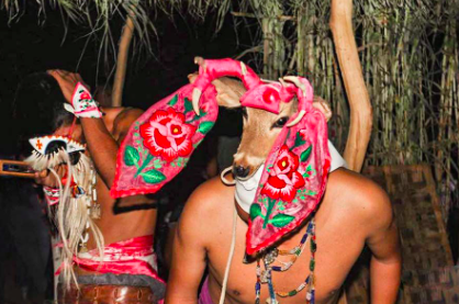
- The Yaqui people have lived in the Gila and Santa Cruz River Valleys for hundreds of years, now having five main communities in Arizona: New Pascua being the reservation, Old Pascua in Tucson, Barrio Libre in South Tucson, Marana northwest of Tucson, and Guadalupe, a southeast suburb of Phoenix.
- The main reservation is in Southwest Arizona near Tucson, being an hour away from Mt. Lemon and a few miles north of Saguaro National Park.
- Yaqui culture bonds both Christianity and Yaqui spirituality. An example of Yaqui ancestral beliefs are seen in the iconic symbol of the deer and the deer dancer who mimics the connection to which Yaqui people have with nature.
- Traditionally, small family plots grew corn, beans, and squash, in addition to trading foods, furs, shells, salt, and other goods with tribes such as the Shoshones, the Comanches, the Pueblos, the Pimas, the Aztecs, and the Toltecs.
San Carlos Apache Tribe

- This community is the "Mountain People" and descendants of the ancients - Nde "The People".
- The reservation spans Gila, Graham, and Pinal Counties in southeastern Arizona, with ancestral lands extending through Arizona and New Mexico.
- Living The Beauty Way, "Walking in Beauty,” the tribe is world-renowned for arts of Basketry, Cradle Board Makers, and Beaded Works.
-
Today, reservation farms grow watermelon, cotton, alfalfa, and jojoba beans, in addition to five tribal cattle associations that raise commercial Hereford cattle.
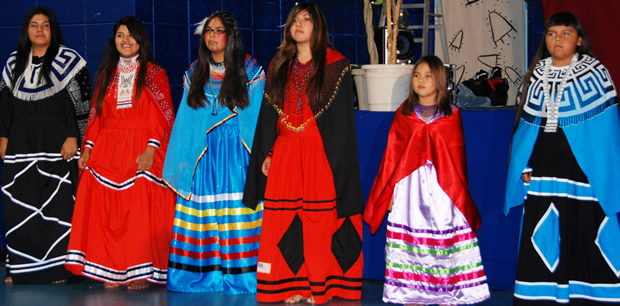
Tonto Apache Tribe
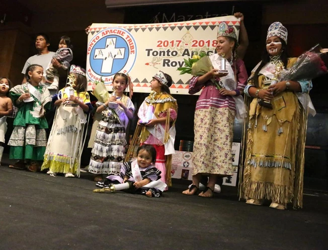
- The Tonto Apache Tribe is a direct descendant of the Tontos who have lived in the Payson vicinity for centuries, originally named Te-go-suk, Place of the Yellow Water.
- This reservation is the smallest land base in Arizona, located in northwestern Gila County approximately 95 miles northeast of Phoenix and 100 miles southeast of Flagstaff, Arizona.
- One of their many community contributions is Frybread for Families, which uses frybread sales to provide Christmas to local families in need.
- Traditionally, tribal members cultivated garden plots along streams in the valleys of the Tonto Basin.
Yavapai-Apache Nation
- The modern Nation is the amalgamation of two historically distinct tribes whose lands overlapped in the Upper Verde Valley: The Western Apache group, Dilzhe’e or popularly known as the “Tonto Apache,” and the Yavapai, or the Wipukyipaya.
- The reservation is located in the Upper Verde Valley of central Arizona off of I-17, 90 miles north of Phoenix and 50 miles south of Flagstaff
- The nation comprises five tribal communities: Tunlii, Middle Verde, Rimrock, Camp Verde, and Clarkdale.
- The tribes maintain a farming and ranch operation at Clover Leaf Ranching and Bald Hill Mountain Range, where alfalfa, tomatoes, squash, chilis, and watermelon are grown, in addition to a small herd of cattle.
Colorado River Indian Tribes
- The Colorado River Indian Tribes (CRIT) include four distinct Tribes - the Mohave, Chemehuevi, Hopi, and Navajo.
- The reservation is located in western Arizona at Parker, 189 miles from Phoenix. It spans the Colorado River and has land in La Paz County, AZ and San Bernardino, CA.
- CRIT has a strong farming and agricultural industry, going back to the days when mesquite trees were plentiful along the banks of the river and were relied upon for food, cooking, and ceremonies.
- Today, there is approximately 84,500 acres of irrigated, fertile farmland growing cotton, alfalfa, feed grains, tomatoes, lettuce, peanuts, and melons.

Fort Yuma-Quechan Tribe
- The Yuma, who today prefer to be called the Quechan (pronounced Kwatsáan), have long lived along the fertile floodplains of the Colorado River.
- The Reservation is located along both sides of the Colorado River near Yuma, Arizona, bordering Arizona, California, and Baja California, Mexico.
- The reservation has Interstate 8 (I-8) running through the south, meaning several million cars a year drive through on their way to and from Phoenix and San Diego.
- There are 700 acres of tribal and allotted lands, most of it is irrigated and leased to non-Indians, providing considerable income for tribal members.

Havasupai Tribe
- Havasuw `Baaja, the people of the blue-green waters, are the traditional guardians of the Grand Canyon and are related to the Yuman.
- The Havasupai Reservation is located in Coconino County, at the southwest corner of the Grand Canyon National Park, consisting of canyon land and broken plateaus abutting the western edge of the Grand Canyons South Rim.
- The remoteness in the canyon means that everything must make the 8-mile trek in and out of the main village, Supai, either by foot or by mule.
- Alongside fields being cultivated by families or individual tribal members with land allotments, 50% of the reservation is classified as range or grazing land, with cattle providing significant tribal and personal income.

Kaibab Band of Paiute Indians
- The Glen Canyon Dam was built within Southern Paiute traditional lands, leading to the forced removal of Southern Paiutes from their lands.
- The reservation is on the northernmost border of the Arizona and Utah border, about 50 miles north of the Grand Canyon, and in-between Coconino and Mojave County in Arizona.
- Most of the businesses on the Kaibab Paiute Indian Reservation are owned and operated by the tribe, alongside a 1,300 tree fruit tree orchard.
- Alongside the tribal orchard with 1,300 fruit trees, many tribal members maintain garden plots, but there is also a large-scale 250-acre alfalfa farming operation.

Pueblo Of Zuni
- The ancestral homelands of the Zunis are along the middle reaches of the Zuni River, a tributary of the Little Colorado River.
- The main reservation is about 150 miles west of Albuquerque in McKinley and Cibola counties in the western part of New Mexico, while also having land holdings in Catron County, New Mexico and Apache County, Arizona.
- Traditional Zuni life is oriented around a matrilineal clan system and a complex ceremonial system with six specialized esoteric groups, each with its own priesthood that is devoted to the worship of a particular group of supernaturals.
- In addition to dryland farming of corn and wheat, Zuni men have been traveling to gather salt from the sacred Zuni Salt Lake for thousands of years.

San Juan Southern Paiute Tribe
- This tribe has inhabited the area south of the San Juan River and east of the Little Colorado for centuries with Paiute Canyon, located in both Arizona and Utah, and is ancestral land.
- This tribe does not have a reservation that is exclusively their own, but there is a treaty with the Navajo Nation to set aside areas in northern Arizona and southern Utah.
- In 2000, Johnny M. Lehi, Sr., President of the San Juan Southern Paiute Tribe, and Kelsey Begaye, President of the Navajo Nation, signed the first treaty that two Indian Tribes have signed with each other in 160 years, which allowed the Paiutes approximately 5,400 acres of land of their own territory within the Navajo Nation.
- Due to the lack of tribal-owned land, they are negotiating land purchases with the Navajo Nation, considering their economy is dependent on livestock and subsistence crop farming.

White Mountain Apache Tribe
- The White Mountain Apaches are closely related to the Apache peoples of San Carlos, Payson, and Camp Verde, while also related to the other Apache nations: the Chiricahua, Mescalero, Jicarrilla, Lipan, and Kiowa-Apache peoples.
- This reservation is located in the east-central region of Arizona, 194 miles northeast of Phoenix, and is located in the Apache, Gila and Navajo counties on the Fort Apache Indian Reservation.
- The ancestral lands are home to the Apache Trout, a species brought back from the brink of extinction through the efforts of the Tribe and many partners.
- There is a 15,000 head tribal cattle herd on the reservation, supported by a 900-acre irrigated farm that grows alfalfa for feed.

Yavapai-Prescott Indian Tribe
- The Yavapai people are known for their exceptional baskets, with their flag featuring a unique and historic basket design.
- The reservation is adjacent to the city of Prescott, Arizona in central Yavapai County, intersected by U.S. Highway 89 and State Highway 69.
- The tribe’s first chief was Sam Jimulla, who was succeeded by his wife Viola, the first woman chieftess among North American Indians.
- Although there are no farming operations present on the reservation, a few tribal members graze personally owned livestock.